GTA 6 WAiNK Locations Guide: All 31 Landmarks & 35 Curiosities Map Checklist for You WAiNKer Trophy and 100%
Pre-installed on Jason Duval and Lucia Caminos' smartphones from the opening hours in the Leonida Keys, the WAiNK app is one of the most important exploration tools in Grand Theft Auto VI. Acting as an in-world crowdsourced scanner, it catalogs historical monuments, bizarre roadside attractions, shipwrecks, and hidden environmental mysteries across the State of Leonida. To unlock the "You WAiNKer!" Silver Trophy (30G Achievement on Xbox Series X|S) and complete the 100% Completion Checklist, you need to log a total of 100 WAiNK scans. Below is our complete region-by-region breakdown of all 31 WAiNK Landmarks and all 35 WAiNK Curiosities, including exact camera targets and bonus loot waiting at each spot.
How the WAiNK App Works & How Many Scans You Need for 100% Completion
Whenever you walk or drive at low speed near a scannable point of interest, your controller vibrates, an audio chime plays, and a notification prompt appears in the bottom-right corner of the screen. Logging a scan takes three quick steps:
- Press D-pad Up to pull out your smartphone and tap the WAiNK app icon at the bottom of the screen.
- Line up the target structure, sign, or object inside the camera viewfinder until the central reticle locks onto the point of interest.
- Hold R1 (PS5) or RB (Xbox Series X|S) for two seconds to register the scan and unlock its lore entry.
You can check your collected entries at any time through the pause menu under Progress > Collections > WAiNK Locations. Across the entire map of Leonida, there are more than 112 scannable locations split into four main categories: 31 Landmarks, 35 Curiosities, 23 Sculptures, and 23 No Flusher Tags. Because you only need 100 total scans in any combination for the trophy and 100% completion, completing the 66 Landmarks and Curiosities below gets you two-thirds of the way there while uncovering the best secrets in the game. You can easily combine these routes with our guide to the 7 best optional side missions in GTA 6 or stop by eastern Grassrivers while solving our Pelican Valley Outpost puzzle and safe code walkthrough. Scanning any 4 locations also completes the dedicated WAiNK Locations exploration challenge.
All 31 WAiNK Landmarks in GTA 6: Region-by-Region Checklist
Landmarks consist of major stadiums, lighthouses, radar domes, observation towers, and historic industrial buildings. Because many of these structures are massive, step back far enough so the main building or its entrance sign fits cleanly inside the WAiNK viewfinder.
1. Vice City & Vice-Dale County (7 Landmarks)
| # | WAiNK Location | Region & District | Exact Location & What to Scan |
|---|---|---|---|
| #1 | Sahara Arena | Downtown Vice City (East Coast) | Scan the large Sahara Arena sign on the front facade of the arena along the eastern Downtown waterfront. |
| #2 | Dock Ring | Downtown Vice City (Shoreline / Catalan Blvd) | Scan the giant Ferris wheel sitting above the water at the end of the eastern Downtown dock off Catalan Blvd. |
| #3 | Downtown Periscope | Downtown Vice City (Catalan Blvd / Mariner's Hwy) | Scan the top of the tall observation structure from the ground floor in the park at the corner of Mariner's Hwy and Catalan Blvd. |
| #4 | IAA's Friends of Freedom | Downtown Vice City (Central Park) | Scan the dedication plaque on the wall next to the listed countries inside the IAA's Friends of Freedom memorial park in central Downtown. |
| #5 | Fleeca Field | Rockridge (West Vice City) | Scan the main stadium sign in front of Fleeca Field in western Rockridge. |
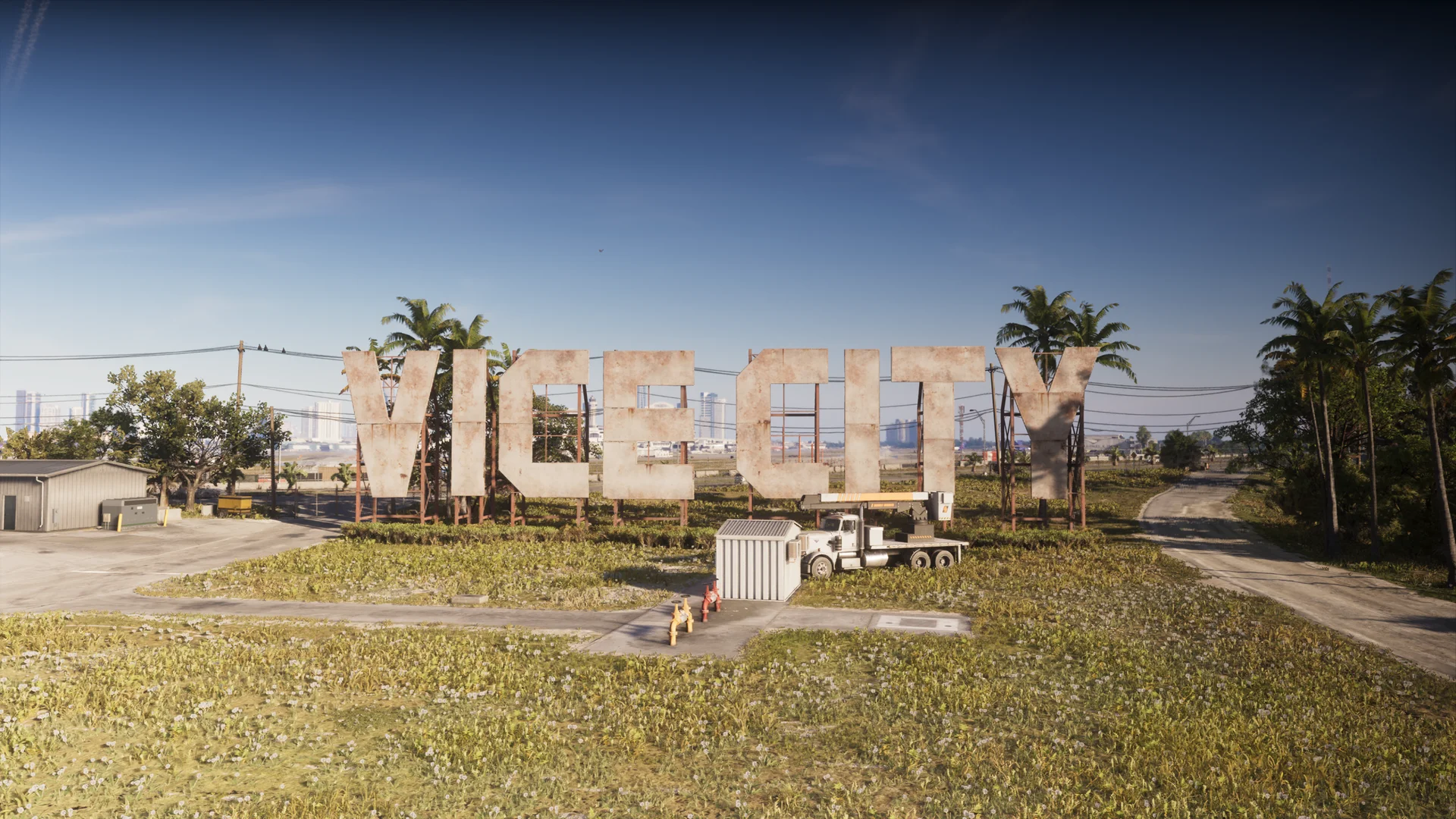
| #6 | Vice City Sign | West Vice-Dale County (Three Toe Lake / VCIA) | Scan the giant letters of the Vice City Sign standing between Three Toe Lake and Vice City International Airport (VCIA). |
| #7 | Pelican Valley Observation Tower | Eastern Grassrivers / Hamlet (Sweetbay Rd) | Climb onto the raised wooden walkway off Sweetbay Rd in eastern Grassrivers and scan the observation tower. |
2. Leonida Keys & Mariana County (7 Landmarks)
| # | WAiNK Location | Region & District | Exact Location & What to Scan |
|---|---|---|---|
| #8 | Badger R&D Tower | Key Lento (Sunset Dr, Mariana County) | Scan the tall concrete radio tower on Sunset Dr in west-central Key Lento, directly across from Donnie's trailer south of Brian's Marina. |
| #9 | Thicc Herbie | Maroon Key / Abismo Key State Park (Mariana County) | Stand in the roadside parking lot along Sunbelt Hwy in Abismo Key State Park and look across the water to scan the massive blimp on Maroon Key. |
| #10 | Riquezas Keys Radome | Riquezas Keys (Southern Island, Mariana County) | Head to the southern facility on the large southwestern island of the Riquezas Keys past Mile Zero Air Station and scan the white radar dome. |
| #11 | Courtland Park Stadium | Catalan Key / Gloriana Key (Mariana County) | Scan the main sign in front of the stadium located in the middle of the Catalan Key main island. |
| #12 | Aqua Stadium | Gloriana Key (Catalan Bay South, Mariana County) | Scan the long waterfront stadium building on the southern coast of Gloriana Key overlooking Catalan Bay. |
| #13 | Bobcat Key Experimental Home | Bobcat Key / Watson Bay (Mariana County) | Along the southern curve of Bobcat Key just offshore in the water, scan the sunken concrete domes of the experimental house. |
| #14 | Belpoint Lighthouse | Belpoint Island (Mariana County) | Take a boat west from Capri to the southern tip of Belpoint Island and scan the tall metal lighthouse structure. |
3. Port Gellhorn, Emerald Springs & Kelly County (7 Landmarks)
| # | WAiNK Location | Region & District | Exact Location & What to Scan |
|---|---|---|---|
| #15 | Gellhorn Fun Fair | Southern Port Gellhorn (Shore Dr, Kelly County) | Scan the center of the rusted Ferris wheel inside the abandoned Gellhorn Fun Fair on Shore Dr north of Oyster Point Gas Stop. |
| #16 | Wild Hog Point Radar Base | Wild Hog Point / Port Gellhorn (Kelly County) | Approach the airfield at Wild Hog Point and scan the spherical dome perched atop the radar tower. |
| #17 | Farmer Scrumpy's Apple Orchard | Manifest Canyon (Kelly County) | North of Rodgers Ranch & Shooting Range in Manifest Canyon, head up the orchard hill and scan the large central barn. |
| #18 | Howe Dairy Farm's Big Udder | Northwestern Emerald Springs (CR 62, Kelly County) | Just south of CR 62 at Howe Dairy Farm in northwestern Emerald Springs, scan the giant cow-print silo. |
| #19 | Sky Ride | Emerald Springs (Emerald River, Kelly County) | In the park along the Emerald River in Emerald Springs (visible looking south from Black Bear Cafe), scan the top of the tall amusement ride. |
| #20 | Tucker's Citrus Farms Water Tower | Northern Emerald Springs (Kelly County) | East of Port Gellhorn inside Tucker's Citrus Farms in northern Emerald Springs, frame and scan the prominent water tower. |
| #21 | Hoffman Observatory | Western North Kelly County | Follow the dirt road to the western peak of North Kelly County overlooking Vice City and scan the abandoned observatory dome. |
4. Ambrosia, Waning Sands, Mount Kalaga & Lummox County (10 Landmarks)
| # | WAiNK Location | Region & District | Exact Location & What to Scan |
|---|---|---|---|
| #22 | Old Goliath | Northwestern Ambrosia (Magnolia Rd & Sycamore Ave) | At the corner of Magnolia Rd and Sycamore Ave in northwestern Ambrosia, scan the massive trunk of the giant tree. |
| #23 | Bonanza Giant | Southern Bonanza / Ambrosia | Hike up the forested hill in southern Bonanza and scan the tall wooden statue standing among the trees. |
| #24 | St. Lucia Lighthouse | Little Hardin Island North (Waning Sands / Leonard County) | Take a boat to the northern tip of Little Hardin Island and scan the sign at the base of the lighthouse. |
| #25 | Unidentified Building | Little Hardin Island South (Waning Sands / Leonard County) | On the small sandy island south of Little Hardin Island, scan the fenced-off entrance door to the underground bunker tunnel. |
| #26 | Lawton Co. Paper Mill | Southwestern Moreau (Adler Creek, Lummox County) | Directly north of the 24/7 Gas West Kalaga station near Adler Creek in southwestern Moreau, scan the ruined paper mill structure. |
| #27 | Outlaw's Cabin | Central Moreau (Rockledge Rd, Lummox County) | On a mountain side street off Rockledge Rd in central Moreau, scan the collapsing wooden cabin. |
| #28 | Grayson Assembly | Downtown Grayson (SR-45, Lummox County) | Along SR-45 in downtown Grayson, directly south of Ledford Motorcycle Workshop, scan the front entrance door of the church. |
| #29 | Grayson Cairns | Mount Kalaga National Park (Lummox County) | At the top of the hill framed by four side roads in Mount Kalaga National Park, scan the stacked stone cairn. |
| #30 | Kalaga Lookout | Mount Kalaga National Park Peak (Lummox County) | On the mountain peak just below the word 'Mount' on the map label, follow the graffiti into the ruins and scan the astronaut painting on the ledge rock. |
| #31 | Tallaloko Amphitheater | Eastern Mount Kalaga National Park (Lummox County) | Inside the ruined amphitheater in eastern Mount Kalaga National Park, scan the central structure housing the bell. |

All 35 WAiNK Curiosities in GTA 6: Locations & Hidden Loot
Tucked away off the main highways, the 35 WAiNK Curiosities highlight Rockstar North's environmental storytelling at its finest. Even better, several of these oddities double as treasure troves holding unique weapons, meteorite chunks, collectible cards, cocaine flamingos, and unlockable vehicle liveries.
1. Leonida Keys, Permit Keys, Capri & Mariana County (12 Curiosities)
| # | WAiNK Location | Region & District | Exact Location & What to Scan |
|---|---|---|---|
| #1 | Christmas House | Key Lento (Sunset Dr, Mariana County) | On Sunset Dr in central Key Lento, scan the house covered in bright holiday lights and Christmas decorations year-round. |
| #2 | Plunge Masters Deep Sea Chalet | Southern Key Lento (Sunset Dr, Mariana County) | Walk behind the Plunge-Masters B.E.N.D.S. Certified Dive Center on Sunset Dr in Key Lento and scan the deep-sea mural on the rear wall. |
| #3 | Vibrant Pond | Gullet Marsh South / Key Lento (Mariana County) | On the southernmost island of Gullet Marsh, scan the Advisory sign standing next to the lake edge filled with dead fish. |
| #4 | Abismo Key Carcass | Abismo Key South Shore (Mariana County) | Along the southern shore of Abismo Key, scan the washed-up skeletal carcass of an unknown creature. |
| #5 | Goose Key Carcass | Goose Key / Mile Zero Air Station (Mariana County) | On the northern shoreline of Mile Zero Air Station on Goose Key, scan the strange creature carcass on the coast. |
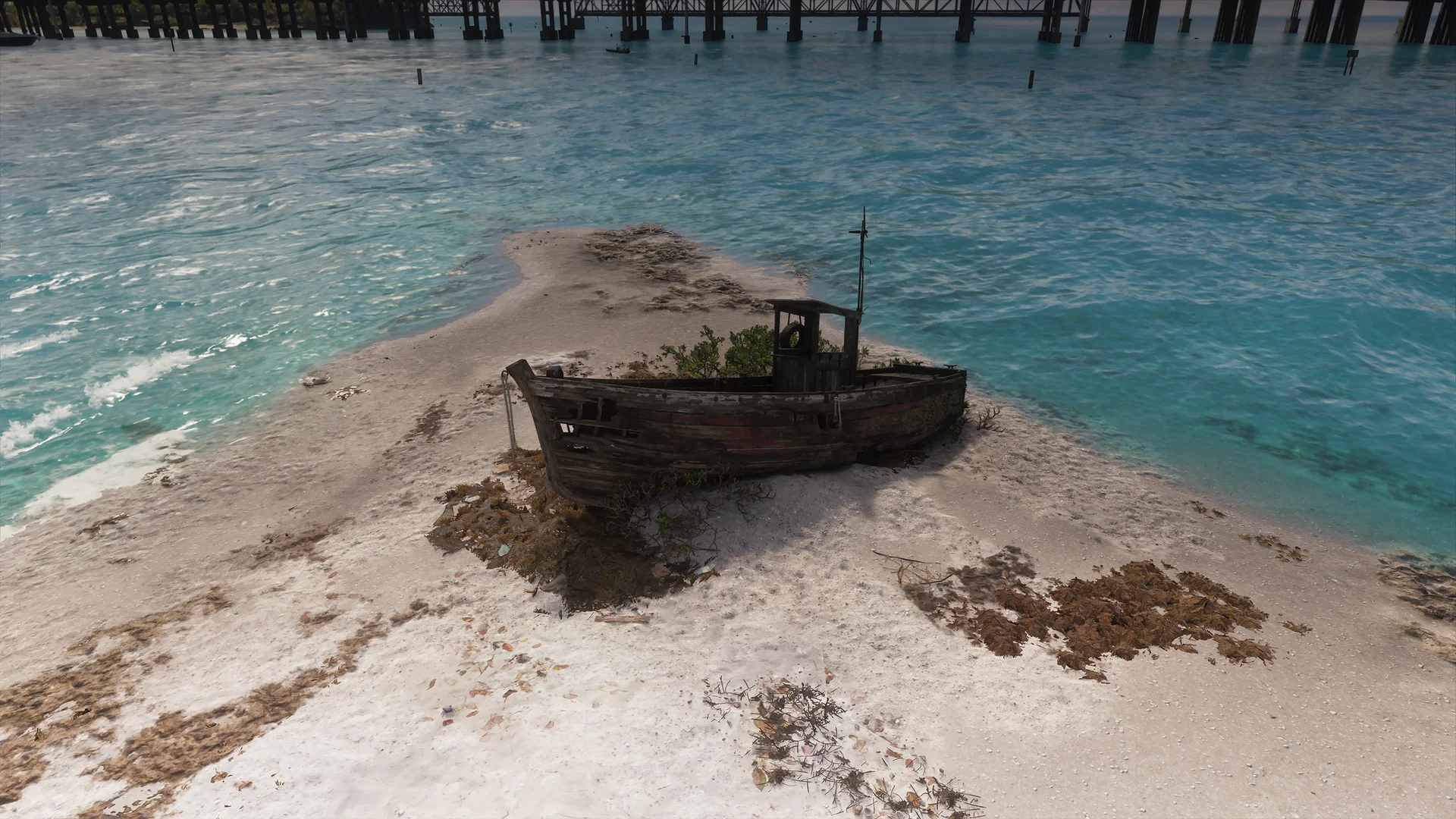
| #6 | Derelict Spy Vessel | Permit Keys (Southeastern Island, Mariana County) | Scan the beached spy ship on the southern tip of the southeastern island in the Permit Keys (board it to loot the Assassin Nipper pistol and an Old Note). |
| #7 | Fingerpost | Permit Keys (Central Island North, Mariana County) | In the sandy northern part of the large central island in the Permit Keys (east of Barrage Gun Supply), scan the wooden signpost pointing to Liberty City. |
| #8 | Beach Party Site | Permit Keys (Central Island East, Mariana County) | Just northeast of the Fingerpost on the eastern beach of the central Permit Keys island, scan the wooden platform (also holds the Pricilla Pace Silver card). |
| #9 | Halloween House | Central Capri (South of Tortoise Lake, Mariana County) | In the middle of the six-street grid south of Tortoise Lake in central Capri, scan the Halloween-decorated house (scanning the parked car unlocks a bonus livery). |
| #10 | Hovercraft Crash | The Sandbars / Crude Islands (North of Belpoint) | On the northern tip of the southernmost island in the Sandbars north of Belpoint, scan the wrecked hovercraft (grab the Glide or Die tattoo magazine by the deck chairs). |
| #11 | Unidentified Animal Pen (UAP) | Northern Watson Bay (Kingston Rd, Mariana County) | Enter the backyard of the light blue house on Kingston Rd in northern Watson Bay and scan the UFO-shaped animal barn. |
| #12 | Desert Island Piano | Western Shoeless Keys (Mariana County) | In the far western area of the Shoeless Keys, land on the tiny isolated island and scan the upright piano sitting in the sand. |
2. Vice City, Grassrivers, Wetman Bay & Waning Sands (8 Curiosities)
| # | WAiNK Location | Region & District | Exact Location & What to Scan |
|---|---|---|---|
| #13 | Big Entrance | Dalton Island (Vice Beach, Vice-Dale County) | In the center of Dalton Island in Vice Beach, walk down the stairs beneath the golden sculpture and scan the Big Entrance plaque on the wall. |
| #14 | Promotional Sand Vehicles | Ocean Beach East (Vice Beach, Vice-Dale County) | Along the eastern shoreline of Ocean Beach in Vice Beach, scan the promotional cars sculpted entirely out of sand. |
| #15 | Mermaid Display | Catalan Key Docks (Vice City Oceanarium) | In the loading dock warehouse of the Vice City Oceanarium on Catalan Key, enter the back room and scan the tank holding the mermaid and humanatee. |
| #16 | Dead Sharks | Wetman Bay (Grassrivers) | Along the shore of a long island in Wetman Bay within the Grassrivers wetlands, scan the cluster of beached dead sharks. |
| #17 | Wetman Bay Carcass | Central Wetman Bay (Grassrivers) | On the southern shore of a central island in Wetman Bay, scan the strange creature carcass resting in the mud. |
| #18 | NoFlusher Homestead | Wetman Bay Y-Island (Grassrivers) | On the Y-shaped middle island in Wetman Bay east of the Fishing Shacks outpost, scan the main homestead cabin. |
| #19 | Belville Topiary | Southern Belville (Harmony Dr, Leonard County) | In the backyard of a white house on Harmony Dr in southern Belville (southeast of the Celerica campus), scan the snake-shaped topiary hedge. |
| #20 | Intriguing Substance | Southern East Lummox County / Waning Sands | Head underneath the staircase leading to the sewer access in southern East Lummox County and scan the glowing green ooze seeping from the wall. |
3. Ambrosia, Port Gellhorn, Emerald Springs & Kelly County (6 Curiosities)
| # | WAiNK Location | Region & District | Exact Location & What to Scan |
|---|---|---|---|
| #21 | Anti Sugar Residence | Western Ambrosia Outskirts | Inside the construction zone just outside the western edge of Ambrosia, scan the lone holdout house protesting the sugar refinery. |
| #22 | Spaceship House | Western Ambrosia (Maple Ln & Cedar St) | At the corner of Maple Ln and Cedar St in western Ambrosia, scan the saucer lander mounted on top of the house (a Legends of Ratface card sits on top). |
| #23 | Dino Golf | Southern Frogswater / Ambrosia | In southern Frogswater, scan the weathered entrance sign for the abandoned Dino Adventure Golf course. |
| #24 | Camp Moonflower | Emerald Springs Dr (Kelly County) | Along Emerald Springs Dr between Emerald Springs and Buckskin Swamp, scan the Camp Moonflower entrance sign. |
| #25 | Deserted Home | Southwestern Emerald Springs (Kelly County) | Near the swamp edge in southwestern Emerald Springs, scan the abandoned house completely overgrown with leaves and vines. |
| #26 | Selkie Hole | Western Emerald Springs (Kelly County) | Take the stairs down to the diving spot on the western edge of Emerald Springs and scan the beam of light from the interior dock (5 meteorite chunks lie in the flooded tunnels below). |
4. Mount Kalaga, Moreau, Featherstone Islands & Lummox County (9 Curiosities)
| # | WAiNK Location | Region & District | Exact Location & What to Scan |
|---|---|---|---|
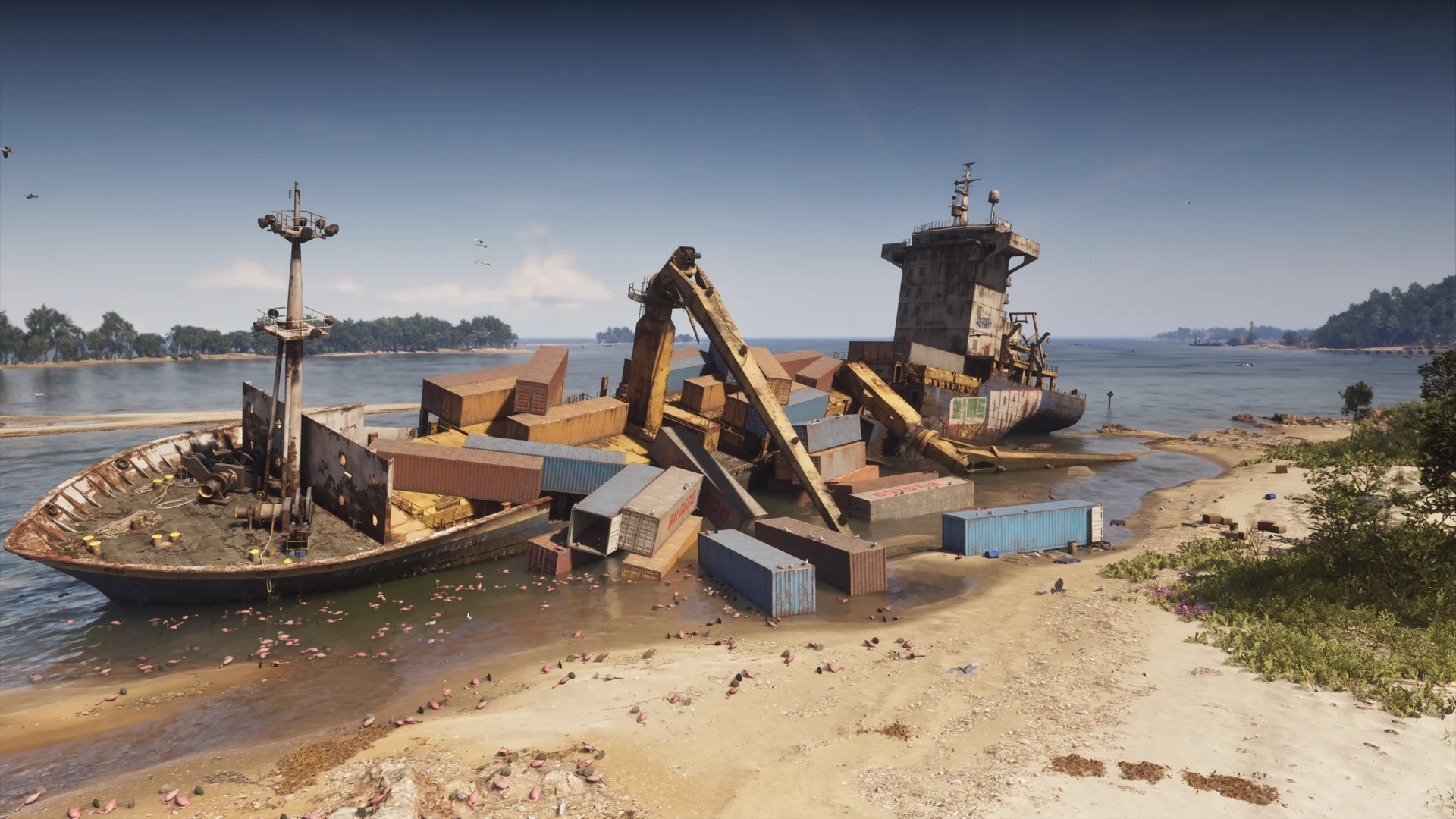
| #27 | Wreck of the Meerwunder | Central Featherstone Islands (Lummox County) | On the north coast of the southeastern island in the Featherstone Islands, scan the capsized cargo ship (3 cocaine flamingos, a meteorite shard, and the Monali$a Silver card are nearby). |
| #28 | C0-B8 Engine | Western Moreau Mountains (MacAlister Gold Mine, Lummox County) | In the western mountains of Moreau near the MacAlister Gold Mine, scan the half-buried C0-B8 rocket engine. |
| #29 | C0-B8 Debris | Featherstone Islands Small Islet (Lummox County) | In the middle of a small island in the Featherstone Islands chain, scan the buried metallic debris of the C0-B8 rocket. |
| #30 | C0-B8 Fairing | Eastern Featherstone Islands (Lummox County) | Along the western coast of the large eastern island in the Featherstone Islands, scan the buried payload fairing of the C0-B8 rocket. |
| #31 | Fossilized Prints | Southwestern Moreau (Adler Creek Bridge, Lummox County) | In the river valley under a bridge northwest of Taco Bomb West Kalaga in southwestern Moreau, scan the fossilized footprints embedded in the rock. |
| #32 | Imperial Spanish Ruins | Western Mount Kalaga National Park (Lummox County) | Atop the southwestern peak in Mount Kalaga National Park (Moreau sector), stand inside the bottom of the ruined stone tower and aim up to scan its top. |
| #33 | Fairy Lane | South West Lummox County Forest | Deep in the forest of South West Lummox County, walk midway between the two wooden arches and scan the red fairy house with open doors. |
| #34 | Lovers Lookout | Southwestern Mount Kalaga National Park (Lummox County) | At the edge of the forest cliff in southwestern Mount Kalaga National Park, scan the wooden arch overlooking the drop. |
| #35 | Pet Cemetery | Southern Grayson (SR-73, Lummox County) | Just off SR-73 in southern Grayson, scan the small row of gravestones inside the hidden pet cemetery. |
My Perspective
After spending hours island-hopping across the Permit Keys and hiking the ridges of Mount Kalaga, I genuinely think the WAiNK app is one of Rockstar's smartest collectible overhauls in years. Instead of forcing us to hunt down a hundred identical glowing packages with zero context, every Curiosity scan rewards you with a piece of weird Florida-inspired folklore and often leads straight to a hidden weapon, a meteorite tunnel, or a rare card. My personal highlight was piecing together the three crashed C0-B8 rocket components between the Moreau mountains and the Featherstone Islands, right next to the massive Wreck of the Meerwunder. If you want to knock out the "You WAiNKer!" trophy efficiently without burning out, start by sweeping Downtown Vice City, Key Lento, and Emerald Springs first: the clustering of Landmarks and Curiosities along those three roads lets you log nearly thirty scans in under an hour.

Grand Theft Auto 6 (GTA 6)
Explore official trailers, technical specs and all latest coverage for Grand Theft Auto 6 (GTA 6).

Based on the outskirts of New York City, Chaya 'Chayane' spent five years studying software engineering in Montreal before returning to her home state. A Full-Stack developer and Deep Learning AI architecture researcher, she explores neural networks and algorithmic optimization while engineering data pipelines for Retrocharting and Gamescharting alongside Grimtag. A gamer for over 20 years and an avid collector of Nintendo history and The Legend of Zelda, she explored World of Warcraft's Azeroth before bringing her deep technical background to video game analysis.